
Reservoir levels
The GRCA owns seven large multi-purpose dams and reservoirs to mitigate downstream flooding and manage river flows.
Water from the spring runoff is stored in the reservoirs to reduce flood peaks. The stored water is then released gradually during dry months to maintain flows.
Gauges at the reservoirs monitor water levels. The information is relayed to the GRCA head office and used to update the charts shown in this section of the website. They are updated every hour.
These gauges are an important part of our flood forecasting and warning systems. They give GRCA flood managers real-time information on changes in water levels so they know how much room is available to hold additional water during high flows. They can manage the levels, releasing water or holding it in as needed to mitigate flooding downstream of the dams.
The gauges have automatic alarms that are triggered by a sudden change in water levels.
The water level charts are also useful to recreational users such as anglers, boaters and others.
Small dams
The GRCA also owns several smaller dams built in the 1800s and 1900s for water supplies, water power and other purposes. These dams, such as Wellesley, New Dundee and Damascus, are not part of the flood control system.
How to read the charts
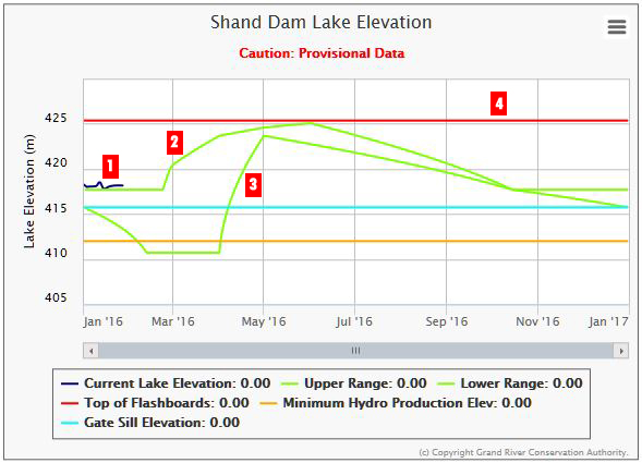
The reservoir charts show changes in water levels over the course of the year.
1. This line shows the current water level.
2 and 3. The green lines are called reservoir "rule curves". The rule curves specify the target elevation of a reservoir for specific times of the year based on specific assumptions or considerations. The reservoir operating policy for the large water management reservoirs in the Grand River watershed, is expressed on a rule curve for each of the seven multi-purpose reservoirs and reflects the need for flood control and low flow augmentation.
The figure above illustrates a reservoir rule curve during the various seasons throughout the year.
4. This is the maximum allowable water level. If water levels get higher, there is a risk that water may flow over the top of the dam, damaging it and possibly causing a dam failure.