


Contact(s)
What caused the flooding?
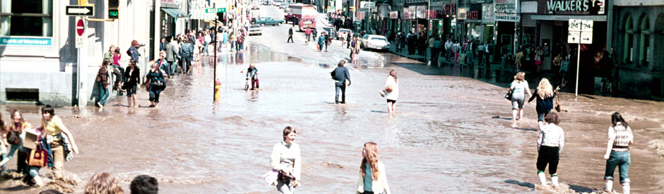
The flooding associated with the June 23, 2017 record rainfall event was the direct result of more than 100 mm of rain falling in the span of two to three hours across a wide section of the northern portion of our watershed.

Rain gauges at Luther Marsh indicated that this was the highest recorded one-day total rainfall for that area since record-keeping began in 1950.
This is an unprecedented volume of rainfall at any time of year, let alone in such a condensed time period, over a relatively large area during the summer.
The rainfall that occurred during this event was not identified in any weather forecasts in advance of the event. Environment Canada did identify a chance of localized, severe thunderstorms in a message put out shortly before midnight on June 22, 2017, but there was no indication that any of those storms would contain rainfall of this magnitude over such a widespread area. The original forecast on the afternoon of June 22 was for 5 to 10 mm of rainfall over areas of the watershed on June 23, 2017.
| Summary of actions taken on June 23 | ||||||||||
|
We operate a sophisticated series of rainfall and river flow gauges throughout the watershed. These gauges are designed to alert staff on-duty 24-hours a day in the event that river flows increase quickly, or heavy rainfall occurs. As a result of the heavy rainfall that occurred on June 23, the following actions occurred.
A series of seven additional flood warning messages were subsequently issued between June 23 and June 27, 2017. These flood messages provided actions and updates to municipal flood coordinators, emergency services and municipal staff as the event unfolded. The same messages were also immediately posted to our website and social media feeds, emailed directly to newsroom subscribers, and sent out to all local media outlets.
|
||||||||||
| What do our reservoirs do? How did they help with this event? | ||||||||||
What do our reservoirs do?
How did our reservoirs help with this event?At this time of year, our reservoirs are approximately 90-96% full to support river flow augmentation. This provides up to 10% of reservoir capacity for flood storage. This additional storage space helped delay peak flows downstream by approximately 2 hours. |
||||||||||
| Why couldn't our reservoirs help to prevent this flood? | ||||||||||
|
Where significant rainfall events are forecast days in advance, water levels in our reservoirs may be drawn down when possible, to help provide additional flood storage capacity. However, there was no advance warning of the significance of this event, and therefore no opportunity to proactively reduce water levels in our reservoirs.
|
||||||||||
| Next steps | ||||||||||
|
Each flooding event is a learning opportunity for our staff, emergency services and municipal flood coordinators throughout the watershed. As with any significant flood, staff meet with municipalities, emergency services, flood coordinators, businesses and residents. From these meetings, improvements to warning systems may be established allowing all agencies to be even more prepared for future flooding events.
|
 Our major