Flood Damage Assessment Study

Grand Valley, Waldemar and Drayton Flood Damage Assessment Study   

Funded in part through Canada’s National Disaster Mitigation Program (NDMP), the Grand River Conservation Authority (GRCA) has completed  a Flood Damage Assessment Study for the communities of Grand Valley, Waldemar and Drayton. The objectives of the study were to estimate average annual flood damages in the three communities and to update flood hazard mapping through the Village of Drayton.

There will be a Public Information Centre for the Grand Valley and Waldemar Flood Damage Assessment Study on Monday, June 22, 2026. Please view the 'Public Information Centre' accordion below for more information.

These three communities are high-risk flood damage centres, given they are located high in their drainage basins (meaning short response times to flooding), limited flood control infrastructure upstream, and the historic development in the floodplain. They are routinely subjected to nuisance flooding and have experienced consequential events in the recent past, notably in 2017, 2018, and 2020.

As part of the study, field work and background information review is expected to include the collection of bathymetric topography (i.e., the surface of the ground underwater), mapping and surveys of selected existing flood-prone buildings and infrastructure, and data related to recent flooding.

The results of this study will help the GRCA, the municipalities, and the property owners better understand and quantify flood-related impacts in these communities and may be used in possible future studies to assess the feasibility (i.e., cost benefits) of potential mitigation options to reduce flood damages.

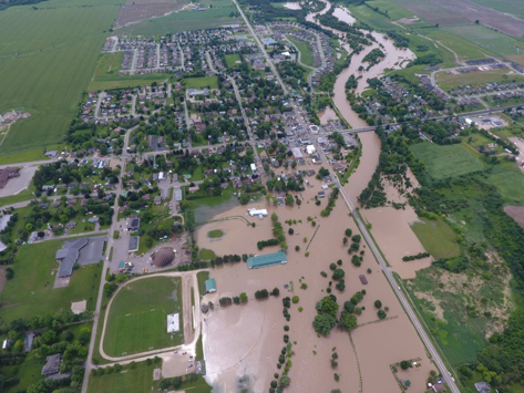
A Flood Damage Assessment Study for Grand Valley, Waldemar and Drayton started in 2022.

A Public Information Centre (PIC) on the results of the Flood Damage Assessment Study for Grand Valley and Waldemar will be held from 7 to 9 p.m. at the Grand Valley and District Community Centre located at 90 Main Street North, Grand Valley, Ontario L9W 5S7. The PIC is open to all and does not require registration to attend. 

The focus of the information session is related to flooding in Grand Valley and Waldemar. The public will have an opportunity to engage with the results of the study and receive information on flood emergency preparedness.

The information session will include a presentation of the results from the study and general information on riverine flooding, including emergency preparedness. This will be followed by an open house, where local municipal staff and Grand River Conservation Authority staff will be available to answer questions.

Information regarding the study results for Drayton will not be covered.

PIC materials will be posted on this webpage as they become available.

If you require accommodations or have questions regarding accessibility, please reach out to:

Kimiko Chhapyan
Water Management Administrative Assistant
kchhapyan@grandriver.ca
(519) 621-2763 extension 2324

As valuable information for the study, the GRCA sought input from community residents and businesses via a survey, which gathered information related to the characteristics of buildings in areas of flood risk (e.g., whether basements are finished), types of flooding residents have experienced (river-related or sewer back-up), and damages and costs associated with floods.

Thank you to those that participated.

This project will result in new floodplain modelling and mapping for the Conestogo River and near shore areas in Drayton. This information may result in amendments to the GRCA’s regulated area mapping under Ontario Regulation 41/24 of the Conservation Authorities Act. 

The new floodplain model and mapping will also support review and potential future updates of flood warning zone mapping for Drayton.  

Consultation on any changes to the regulatory floodplain and regulated area mapping will be held during the PIC that will be held for this study in the Village of Drayton.

The National Disaster Mitigation Program is a federal program established in 2015 with the aim of reducing the impacts of natural disasters on Canadians. The NDMP was established to reduce the impacts of natural disasters on Canadians by focusing investments on significant, recurring flood risk and costs, and advancing work to facilitate private residential insurance for overland flooding.

Contact Us

Grand River Conservation Authority
400 Clyde Road, PO Box 729
Cambridge, ON
N1R 5W6
Phone: 519-621-2761
Toll Free: 1-866-900-4722
grca@grandriver.ca